
Treasured Rivers of Pocahontas County
Greenbrier River
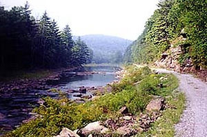
The Greenbrier River rises in the high mountains of Pocahontas County, West Virginia, where the East and West Forks begin at elevations above 3,600 feet before joining at Durbin to form one of the longest free-flowing rivers in the eastern United States. From its pristine headwaters, the river flows generally southwest through Pocahontas, Greenbrier, and Summers counties before meeting the New River at Hinton, contributing to the larger Mississippi River watershed.
Scenic Beauty & Outdoor Recreation
The Greenbrier River is celebrated for its scenic valleys, forested ridges, and abundant wildlife, offering outdoor enthusiasts year-round adventure and relaxation. Anglers enjoy excellent smallmouth bass and other warm-water fisheries as the river’s warm, clear waters wind through rural landscapes. wvoutdooradventures.com
A major highlight along the river is the Greenbrier River Trail — a 77+ mile rail-trail that parallels the river from Cass through Pocahontas County toward North Caldwell, providing exceptional opportunities for hiking, biking, horseback riding, and nature observation with bridges, tunnels, and riverside views at every turn.
Rich Natural & Cultural Legacy
Flowing largely through the Monongahela National Forest in its upper reaches, the Greenbrier River traverses landscapes shaped by ancient forests, limestone valleys, and karst geology rich with caves and springs. Its historic valleys were early corridors for Native American trails and later for European settlers, shaping the heritage of communities along its banks.
Why the Greenbrier River Matters
From its birth in Pocahontas County’s highlands to its confluence with the New River, the Greenbrier River offers a quintessential West Virginia river experience — from peaceful waters and abundant wildlife to recreation and rural charm. Whether you’re casting a line, pedaling the rail-trail, or simply taking in riverside views, the Greenbrier River is a treasured natural gem of the Mountain State.
Williams River

The Williams River begins on Black Mountain in Pocahontas County, West Virginia, flowing approximately 33 miles westward through the heart of the Monongahela National Forest before joining the Gauley River near Cowen in neighboring Webster County. This scenic tributary winds through rugged highland terrain, lush forests, and peaceful valleys, offering visitors a true Appalachian river experience.
Nature & Outdoor Recreation
Renowned for its pristine waters and abundant trout, the Williams River is considered one of West Virginia’s premier trout fishing streams, attracting anglers from near and far for year-round fishing opportunities in clear, cold water. The river supports brook, rainbow, and brown trout, with excellent habitat and scenic angling access throughout its course.
Along the river corridor, outdoor enthusiasts will find abundant opportunities for hiking, camping, wildlife viewing, and mountain biking. Rustic campsites dot the river along Williams River Road (Forest Roads 86 and 216), providing quiet places to stay near the water and immerse yourself in nature.
Adventure & Scenic Beauty
For paddlers and paddling adventurers, select sections of the Williams River offer intermediate whitewater runs with exciting Class III–IV rapids, backed by densely forested hillsides and a sense of wild solitude that captures the spirit of the highlands. diyoutdoors
The surrounding Tea Creek Recreation Area and trail systems also bring sensory delights for hikers and nature lovers, with trails that meander through spruce and aspen groves, open meadows, and scenic overlooks — making the Williams River watershed a year-round destination for active exploration.
A River of Quiet Wilderness
Flowing from its headwaters high on Black Mountain, the Williams River serves as a gateway to West Virginia’s unspoiled outdoor heritage. Whether you’re casting a line into a deep pool at dawn, paddling through forest-lined rapids, or gathering around a campfire under starlit skies, the Williams River — flowing through Pocahontas County is a treasured gem of the Mountain State’s wild and scenic landscape.
Cranberry River

The Cranberry River originates in the high, forested slopes of Pocahontas County, West Virginia, where its North Fork rises near Black Mountain and the South Fork begins on Cranberry Mountain — flowing through the unique Cranberry Glades Botanical Area before uniting to form the main stem of this scenic Appalachian waterway. From its headwaters, the river travels approximately 24 miles through remote wilderness and lush forestland before joining the Gauley River near Woodbine, contributing to the greater Mississippi River watershed via the Gauley, Kanawha, and Ohio rivers.
Nature, Scenery & Wild Heritage
The Cranberry River winds through some of West Virginia’s most unspoiled natural landscapes, much of it within the Monongahela National Forest and bordered by the expansive Cranberry Wilderness. This rugged region showcases high-elevation forests, rolling mountain ridges, and pristine river corridors that provide habitat for diverse wildlife and a true sense of Appalachian wilderness.
The river’s name comes from the cranberry bogs that once — and still — thrive along its course, especially near the Cranberry Glades where unique northern-type plants flourish alongside sphagnum mosses and bog-adapted species in a rare southern Appalachian ecosystem.
Outdoor Adventure & Recreation
The Cranberry River is cherished by outdoor enthusiasts for its exceptional trout fishing, with cold, clear waters that support thriving brook and rainbow trout populations. Anglers from across the eastern United States come to fish its scenic runs and pools.
Recreation along the river also includes hiking, camping, swimming holes, and whitewater paddling, with Forest Service roads, campgrounds, and picnic areas providing access to many memorable spots for adventure and relaxation alike. diyoutdoors.
A River of Quiet Wilderness
Flowing through a landscape shaped by deep valleys, spruce-covered ridges, and time-worn trails, the Cranberry River offers a tranquil and inspiring waterway that captures the wild spirit of West Virginia’s highlands. Whether you’re casting a line at dawn, exploring backcountry trails, or simply taking in riverside views, the Cranberry River — born in Pocahontas County — is a treasured natural gem of the Mountain State.
Cherry River

The Cherry River begins its journey in the high, forested slopes of Pocahontas County, West Virginia, where its two main sources — the North Fork Cherry River and South Fork Cherry River — rise amid the rolling peaks and pristine woodlands of the Monongahela National Forest. From these headwaters, the river flows west-northwest across rural and scenic terrain before joining the Gauley River downstream, contributing to one of West Virginia’s vital river systems that eventually feeds into the Mississippi Watershed.
Natural Beauty & Outdoor Recreation
Winding through Appalachian hardwood forests and rugged mountain landscapes, the Cherry River is beloved by outdoor enthusiasts for its tranquil beauty and adventure opportunities. Anglers find excellent fishing along its clear waters, while paddlers enjoy a novice to intermediate whitewater run with Class II–III rapids, making it ideal for kayaking, canoeing, and scenic paddling excursions.
Rich Forest & River Corridor
Much of the Cherry River flows through the Monongahela National Forest, where shaded riverbanks, abundant wildlife, and lush natural settings create an inviting backdrop for hiking, birdwatching, and riverside picnics. The river also parallels the Cranberry Tri-Rivers Rail Trail in parts of its course, offering easy access and multi-activity recreation for visitors.
Community & History
The town of Richwood, located near the confluence of the North and South Forks, grew historically around the Cherry River and its surrounding forests — once known as Cherry Tree Bottoms due to the abundance of wild cherry trees along its banks. Today, the river remains an important cultural and natural landmark for local residents and visitors alike.
Whether you’re seeking peaceful riverside views, exhilarating paddling, or memorable fishing spots, the Cherry River — born in Pocahontas County — captures the wild spirit and scenic charm of West Virginia’s Southern Highlands.
Shavers Fork of Cheat River

The Shavers Fork of the Cheat River begins high on the Allegheny Mountains in Pocahontas County, West Virginia, near Thorny Flat on Cheat Mountain — among the highest elevations in the state and home to the renowned Snowshoe area. From these cool mountain headwaters, Shavers Fork embarks on a scenic 88-mile journey northward through dense forests, deep river valleys, and the heart of the Monongahela National Forest, before meeting the Black Fork at Parsons to form the classic Cheat River.
A River Born in the Highlands
Shavers Fork’s source lies near 4,553 feet above sea level, making its upper reaches among the highest-elevation river waters in the eastern United States. As it flows out of Pocahontas County, the river is embraced by vast, largely untouched forestland — over 97 % of the watershed remains wild and two-thirds of it lies within public lands — creating an environment rich with biodiversity and natural beauty.
Nature & Recreation
This pristine river is treasured for its outdoor opportunities. Anglers flock to Shavers Fork for exceptional trout fishing in its cool, clear waters. Paddlers and kayakers enjoy stretches of Class I–IV whitewater, while calm sections invite canoeing, tubing, and peaceful floating under towering Appalachian forest canopies. The river corridor also offers trail access, scenic overlooks, wildlife sightings, and quiet riverbank spots for camping and photography.
Landscapes & Legacy
Flowing through some of West Virginia’s most iconic mountain terrain, Shavers Fork showcases dramatic highland scenery — from the narrow valleys carved between Cheat Mountain and Shavers Mountain to serene forest stretches that trace the contours of the land. Its journey feeds into the greater Cheat watershed, ultimately connecting to the Monongahela and Ohio rivers and beyond.
Whether you’re seeking thrilling outdoor adventure, peaceful natural retreat, or a glimpse into the wild heart of the Mountain State, the Shavers Fork of the Cheat River — born in Pocahontas County — offers an unforgettable river experience rooted in West Virginia’s rugged highlands.
Elk River

The Elk River rises high in the Allegheny Mountains of Pocahontas County, West Virginia, where two mountain streams — the Old Field Fork and the Big Spring Fork — converge near the Slatyfork area to form the headwaters of this remarkable Appalachian river. From its origins surrounded by the lush forests of the Monongahela National Forest, the Elk begins a winding journey that will carry its clear waters more than 170 miles across the state.
Flowing generally northwest and then westward, the river meanders through some of West Virginia’s most scenic and varied landscapes — from cool, high-elevation trout streams and limestone “dries” where the river briefly flows underground, to broad valleys and gentle shoals downstream.
A River of Nature & Recreation
The Elk River watershed supports outstanding water quality and diverse aquatic life, making it a favorite among anglers, paddlers, and wildlife lovers. Its upper stretches are renowned for trout fishing, while the middle and lower reaches offer abundant smallmouth bass, muskellunge, walleye, and other game fish.
Across its course, the Elk provides opportunities for canoeing, kayaking, floating, and scenic water trails, with convenient access points and plenty of riverside beauty to explore.
From Mountain Source to Big Water
As the river continues westward, it feeds Sutton Lake, a broad reservoir created by the U.S. Army Corps of Engineers, and then flows past small towns and wooded valleys until finally joining the Kanawha River at Charleston, connecting its waters all the way to the Ohio and Mississippi rivers.
Why Elk River Matters
More than a scenic waterway, the Elk River is a lifeline for communities and ecosystems. Its waters serve as a source of drinking water, support thriving fisheries, and anchor local outdoor traditions rooted in West Virginia’s mountain heritage.
Whether you’re seeking peaceful natural scenery, adventurous outdoor pursuits, or a deeper connection with West Virginia’s riverscape, the Elk River — beginning here in Pocahontas County — is one of the state’s most treasured waterways.
Gauley River

The Gauley River begins high in the Allegheny Mountains of Pocahontas County, West Virginia, where crisp streams rising on Gauley Mountain and across the surrounding highlands join to form one of the Mountain State’s most iconic and powerful rivers. From its headwaters, the Gauley plunges nearly 4,000 feet over its 105-mile journey through rugged canyon country and verdant Appalachian forests before meeting the New River at Gauley Bridge and helping form the mighty Kanawha River.
A Natural Wonder & Outdoor Destination
The Gauley flows through treasured landscapes within and beyond Pocahontas County, including deep gorges and broad forested valleys. Downstream, the river winds through the scenic Gauley River National Recreation Area, where approximately 25 miles of free-flowing river showcase dramatic Class V+ rapids, narrow canyon walls, and endless opportunities for adventure.
Adventure & Recreation
The Gauley River is world-renowned among paddlers and outdoor enthusiasts for its thrilling whitewater rafting and kayaking, especially during the annual Gauley Season—a series of scheduled dam releases in early fall that produce some of the most exhilarating rapids in the eastern United States. Beyond whitewater, the river corridor offers excellent trout and warm-water fishing, scenic hiking, wildlife watching, and peaceful stretches for canoeing and river excursions.
Wildlife & Landscape
Winding through the heart of West Virginia’s forested highlands, the Gauley supports rich ecosystems and abundant wildlife. Its headwaters near Pocahontas County lie within the Monongahela National Forest, an area known for old-growth forests, sparkling headwater streams, and exceptional outdoor biodiversity.
Heritage & History
For centuries, the Gauley River region provided hunting and fishing grounds for Native American peoples and later frontier settlers. The river’s landscape also witnessed pivotal moments in early West Virginia history, including Civil War engagements along its banks.
Whether you’re seeking adrenaline on Class V rapids, fishing quiet bends of clear water, or simply soaking in Appalachian mountain beauty, the Gauley River stands as a breathtaking natural treasure rooted in West Virginia’s storied highlands.
Tygart River

The Tygart River begins high in the Allegheny Mountains of Pocahontas County, West Virginia, where pure mountain springs and forested slopes feed this iconic Appalachian waterway. Rising near the Randolph–Pocahontas county line, the river’s headwaters flow northward through some of the most rugged and unspoiled terrain in the eastern United States, carving a path through breathtaking wilderness and rich hardwood forests before eventually joining larger river systems to shape the region’s natural heritage.
As the river flows out of Pocahontas County, it becomes part of the Tygart Valley River, a major tributary of the Monongahela River that drains more than 1,300 square miles of predominantly rural landscape.
What Makes the Tygart Special
Headwaters in the Alleghenies: The river’s source near Valley Mountain begins amidst high-elevation forests and rolling hills, offering pristine water quality and a sense of true wilderness. wvencyclopedia.org
Outdoor Recreation: The Tygart’s cool, flowing waters support fishing, kayaking, canoeing, and wildlife observation. Anglers enjoy trout and warm-water fisheries, while paddlers and nature lovers are drawn to the river’s scenic valley corridors. Elkins-Randolph County Tourism
Natural Connectivity: The river contributes to a larger watershed that eventually helps form the Monongahela River—linking the mountains of West Virginia to the broader Appalachian river system. Wikipedia
Whether you’re seeking peaceful riverside views, adventurous paddling, or a deeper connection with West Virginia’s natural roots, the Tygart River stands as a timeless symbol of the Mountain State’s wild beauty.